 Live Music Archive
 Librivox Free Audio
 Metropolitan Museum
 Cleveland Museum of Art
 Internet Arcade
 Console Living Room
 Books to Borrow
 Open Library
 TV News
 Understanding 9/11
tv News 4 Midday NBC February 5, 2010 11:00am-12:00pm EST
11:00 am

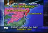
right now, the snow has started to fall in parts of our viewing area. before the storm has moved out, it could leave behind more a foot of snow. >> the storm has prompted many people to hit the stores and now many of those stores are nearly empty. >> and an army of snow-removal equipment is ready to go out there. many trucks are already stationed along the highways, waiting for the snow to fall. ne "news 4 midday" begins right now. good morning to you. welcome to "news 4 midday." i'm joe krebs. >> and i'm barbara harrison. it's friday, february 5th, 2010. we begin this morning with a major winter storm that could bring a foot or two of snow to some areas. winter storm warnings run from
11:01 am
virginia into maryland, parts of west virginia, pennsylvania, new jersey, and ohio this morning. it has already started to snow in parts of virginia and right here in the district as well. we're looking live, though, at route 29 in centerville. here in the district, we're also seeing some flakes starting to fly. skies are pretty gray out there. >> they are, indeed. let's get a first forecast now from meteorologist tom kierein. he, of course, has been tracking this storm for several days. tom? >> hey, tom. >> hey, barbara and joe. good morning. we've been tracking this storm and we've been seeing some copious amounts of moisture coming in off the gulf of mexico. that's why we're forecasting such high amounts of snow. look at all of this rain, getting heavy downpours in georgia, northern florida, that's just about to move into south carolina. then it runs into cold air in place right over our region. and that rain turns into snow. and that is now beginning to increase in its intensity. the snow is now falling moderately, right around roanoke, lynchburg, blacksburg, and southwestern virginia.
11:02 am
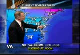
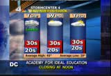
now, the local radar is showi some light snow falling in washington and acros northern virginia, now moving into maryland and the panhandle of west virginia and the shenandoah valley. observers and weather watchers all around the region now reporting that the snow falling lightly around if region. temperatures are at or a little bit above freezing. so initially it's not going to stick, but it will eventually get the temperatures down below freezing. charlottesville right now below freezing, as is winchester. now 35 in washington. and on the eastern shore. and it's right near the freezing mark, roanoke and richmond, their getting the snow. norfolk, they're at 41, they're going to get mostly rain, they have no warnings there. but the rest of virginia is under a winter storm warning as is all of maryland. those counties in red on the eastern shore, the jersey shore, blizzard warnings. they could get winds 30 miles an hour there with heavy snow. certainly blizzard conditions there. for us, we'll have the snow
11:03 am
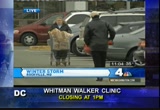
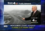
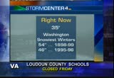
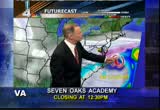
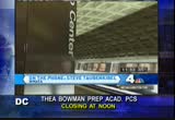
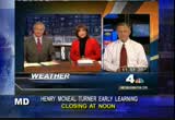
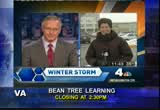
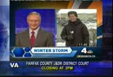
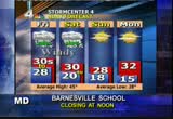
continuing into the afternoon by sunset. we could have 3 to 5 inches on the ground by sunset. the winds will increase as well. we'll fall out of the mid-30s where we are now and be below freezing by overnight tonight i'll show you how much i am expecting from this storm. we'l take a look at the time line and look at what's going to happen before the storm goes by as well. barbara and joe? >> thanks very much, tom. many schools and businesses are closing early today so people with get home before this storm begins. the federal government is operating with a four-hour early dismissal in effect. d.c. public schools will close at noon today. taking a look at som other school systems in maryland, prince george's county schools will close three hours early. montgomery county, 2 1/2 hours early. and arundel county schools will close two hours area. carroll county, 2 hours, 45 minutes early. frederick county schools will close 3 1/2 hours early. washington county schools, 2 1/2 hours early. and most school in virginia are closed today because of this storm.
11:04 am
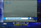
all early dismissals and closings will be running at the bottom of your screen. well, many people have been rushing to the grocery stores to get enough food and supplies to last them through the storm. chopper 4 flew over a giants store and a parking lot there in wheaton just a short time ago and the lot was packed, as you can see. that seems to be the case in most storms this morning. news 4 megan mcgrath is in rockville with more onhis last-minute rush. have you got all your supplies yet? >> reporter: i have. i must commit, over the last couple of days working, i've grabbed a few things here and there, so i think we're prepared in our household. but this place is packed. we're here at the 24-hour giant on montrose and look at this parking lot. it looks like christmas at the mall. people are getting a little aggressive about getting parking spaces. before we went on air, someone was blowing on their, trying to get someone else out of their way.
11:05 am
we've got people walking down the center of the lanes with all of their groceries and people are starting to get a little grouchy here. we have had activity all night long. as i mentioned, this is a 24-hour giant. and i'll tell you, in the middle of the night, there were actually people here. not just a couple, a lot of people here. everybody stocking up for the big storm. >> $139.29. >> reporter: a shopping frenzy as people race to their local grocery stores to stock up on food ahead of the storm. >> just a few last-minute things that we thought of above the weather gets bad here later today. >> reporter: at this 24-hour giant in rockville, they were doing a brisk business at 1:30 in the morning. >> we had about six cashiers on until about 1:30 in the morning, and it was about eight or ten deep, pretty much, for some hours there. >> reporter: with so many people buying so much, stores across the region are getting slammed.
11:06 am
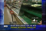
just look at this produce aisle. many a shopper has been forced to hit more than one store to get what they need. >> there's no meat, so i'll be going to another grocery store, hopefully. >> reporter: tell me, were you finding what you needed? >> i found what i needed, i just needed meat to cook for dinner. i found everything else. >> a lot of stuff is all gone. a lot of fruits and the meats and all the good stuff is gone. >> reporter: and with the coming of the gray sky has come a sense of resignation. folks say they're ready. >> kind of excited, but i hope it comes, since i am up this early, you know? but, yeah, kind of excited about it and everything. >> reporter: how do you feel about 18 to 24 inches of snow? >> well, the problem is going to be when i have to shove it from the driveway. but after that, just hunker down, enjoy the football game, and we're all done. >> reporter: and you can see folks loading up their groceries. and while they do that, someone's sitting right there with their blinker on, waiting to steal that spot. that's how crowded it is here in
11:07 am
this parking lot. and inside, also packed. and you better mind your line etiquette, if you don't go where yore supposed to go, people will call you on it immediately. and it's confusing, the lines are zigging and zagging, there's a break and then they continue and zig zag down the actual aisles where the groceries are and that's a little confusing for some folks and some people think, oh, they think the break is the end and they go and get into that line and you hear everyone at the back going, hey, hey, so people are starting to get a little grouchy to get what they need and get out of there and get home. as you can see, we're starting to see some light snow. that srted probably in the last 15, 20 minutes or so. >> barbara, back to you. >> one of the guy you talked to mentioned the game. i hear a lot of people around here worried about not getting their munchies for sunday. >> reporter: and i know people who are trying to have super bowl parties. i don't know, your guests will have to have dogsleds to make it
11:08 am

to your house. >> we've heard that from a few people here too. thanks a lot. talk to you later. metro may be the only way to get around this week, and only then you'll likely run into some serious difficulties. metro is operating on normal schedule at the moment and it will continue to run normally until there are 8 inches of snowfall. after that, above-ground service will be shut down. >> given what the anticipated snow total amounts are going to be for the weekend, it is highly probable that we will suspend all of our above-ground rail service for the entire weekend. it is also highly probable that we will suspend all of metro bus and metro access service, certainly all day saturday. and that could extend into sunday as well. >> and if above-ground rail service is suspended, metro will operate on a modified, underground schedule will trains running only every 30 minutes. well, vdot says the last storm blew its budget, but crews will be out clearing the roads,
11:09 am

no matter what. workers got an early start pretreating the roads and stocking up on salt. vdot is tapping into $25 million reserve fund to pay for all this. in maryland, state highway officials say they have already spent some $50 million on snow removal this year and that is almost double their annual budget. they say weekend storms are also more expensive because of the long hours and the high overtime costs. crews in the district are preparing for anoth long weekend. a snow emergency took effect at 9:30 this morning. that means all cars must be moved from any snow emergency route. 270 trucks will be salting and plowing the streets during the storm. if your car is still parked in an emergency route during the storm, it will be ticketed and it will be towed. speaking of ticket and towed, let's talk about cars. here's jerry edwards and the news 4 traffic network. >> hey, barbara and joe, good morning. we'll start over in northern virginia, along and 395. right now, the snow is coming
11:10 am
down. so far, because of the pretreating of the roadways, just wet. but we'll have to watch throughout the day and into tomorrow morning. bridges, ramps, overpasses, they have a tendency to freeze up first. that's how it's looking over in virginia. on the east side of town, beltway in landover, snow hasn't moved in there yet, but it won't be long. both inner loop and outer loop, dry pavement between the wilson bridge and college park, but we'll keep an eye on that throughout the hour. >> thanks, jerry. the winter weather blast will have a major effect in the skies. air travelers could be in for some massive delays if they get out of town at all. cancellations are certainly in the works, and many passengers are currently trying to change their flights. tracee wilkins join us live from reagan national airport with more on the last-minute rush. tracee, good morning. >> reporter: good morning, joe. things have slowed down here at reagan. that's because people got here early this morning, trying to take care of those rebookings and trying to get on some other flights. this all started after southwest airlines made that announcement yesterday, that ned no plans on
11:11 am
flying any planes out of bwi and dulles this afternoon and this evening, that they were also canceling all of their service for saturday and they were planning on canceling some for early sunday morning. so folks rushed to try and get some other flights. now things are calming down just a bit, as the snow is starting to fall. plenty of folks already in the sky making their way out of d.c. there was a traffic jam this morning in the arrival lanes to reagan national airport. would-be passengers scrambled for early morning flights out of town, all trying to beat the looming storm. >> i got here early enough, but apparently not. >> i did get a flight. it was hard to get a flight and i think i probably got one of the last seats out of here. >> reporter: for some who were trying to make last-minute flight changes, they showed up early, still unsure if they'd actually have a seat. did you have to rebook? >> no, i'm hoping to, but the way things are now, there's probably not much chance. my flight's delayed. there's one that goes out earlier, and i'm hoping to snatch a seat on that.
11:12 am

hoping, crossing my fingers. >> i'm worried. i've got a 6:00 flight, i've been on three lines and i don't have the answer yet. they told me i do have a seat, but i have to go to the counter. the kiosk is not working. i'm very worried. >> reporter: and just when it seemed many passengers were booked and in the clear, then there was this. yet another traffic jam, this time at the security checkpoint. >> i think this is crazy. i live in atlanta and our airport is so much busier and we're never quite like this for a storm. i'm just hoping i get on my flight. >> reporter: for some folks making last-minute changes, it was easy thanks to relaxed policies by the airlines. but for others -- did you have any issues getting your flight? >> no, not at all. actually, they waived the rebooking fee, which was great. >> reporter: did you have the same experience? >> though, they charged me a rebooking fee. >> reporter: oh, i'm sorry. >> but i'm happy to be getting home. i was supposed to leave at 6:40 this evening, so i don't think i would have gotten out at that
11:13 am
time. >> reporter: and now you can see why she would think that. take a look here at national airport. the visibility is just not great. we've got this snow coming down already. they have already cancelled a couple of 1:00 p.m. flights here, so these cancellations are starting to take effect because of the weather and we're expecting that it's only going to get worse. as i said, a lot of passengers already figuring that out. we're not seeing as many people out here. as you saw in that video, it was unbelievably packed this morning. i can't remember the last time i saw reagan so packed, so many people trying to get out of town. if you're still trying to rebook or reschedule a flight and want to see if you can make it out, make sure that you call your airline before you come down, because it's just going to be very difficult, especially with more cancellations expected. i'm tracee wilkins, live at reagan national airport. back to you all in the studio, joe. >> tracee, thanks very much. reagan wasn't the only place travelers were up early, looking to get out of town before the storm. passengers headed out to dulles as well, hoping their flights were not canceled there. there could be massive
11:14 am
cancellations, though, today, as this winter weather does approach. 14 minutes after 11:00 is the time right now. food and water are not the only supplies you should be thinking about ahead of the storm. coming up, there are some critical items that you should have in your house. that list, we'll tell you about it, ahead. plus, the snow started early in parts of north carolina. a look at the other areas being hit by thimassive storm and the radar shows this massive storm starting to move into our area now. tom kierein will be back with us in just a minute for a closer lo ó>ó>ó>ó>ó>ó>ó>gó>ó>ó>ó>ó>ó>ó>ó>>


11:17 am

you no doubt will hear this a lot this weekend, if you don't have to go out this weekend, it's best to stay inside, out of the cold, during today's storm. but here's some information to keep in mind if the storm keeps you homebound for a few days. news 4's elaine reyes joins us with some emergency tips. >> the snow not bad yet, but when it piles up and the ice and the wind gets involved, that's when the problems start. this is common sense, but here are a few reminders in case your power or utilities go out during the winter storm. we've been talking about the busy grocery stores during the last day or so, keep some extra food on hand, especially the kind that doesn't require refrigeration or cooking. and it doesn't hurt to have plenty of bottled water. remember, pipes can burst and water main breaks are not fun. check your precipitatiscription and make sure you have enough for at least a week. store shelves are starting to empty across the metro area, so take a look at your first aid
11:18 am

supplies. your flashlights, candles, extra blankets. do you have enough batteries for a portable radio? and consider having an alternate heating source, such as a kerosene heater or something else as a backup in case your power goes out. if you do decide to venture out in your car at some point, consider stocking it with supplies as well. you'll need a shovel or a scraper to dig out, flashlight, extra batteries, water, snacks, extra clothes, first aid, and emergency flares. of course, no one ever expects to get stuck in their cars, it's just much easier to be prepared. some other things to keep in mind. of course, keep your cell phone charged. you just never know. and don't forget to check on your elderly neighbors who might be nearby. they might not be able to get out. back to you guys in the studio. >> good advice. i'll have to go pick up another scraper. i lost mine last week. thanks a lot, elaine, for those tips. stafford county in virginia
11:19 am
is opening two shelters during the storm. the shelters will be at stafford high school and north stafford high school. they will be managed by staff from the red cross. residents who have experienced many power outages in their homes during weather events like this do not have backup heating sources and especially those with medical equipment that relies on electricity should really consider using one of these identified shelters. the shelters will be open as of noon today, about 40 minutes from now, they'll remain open as long as they are needed. and that winter weather is moving in from the south. this is video from blowing rock, north carolinaand it is blowing down there. tom says this is what we're going to look like pretty soon. he says bwing rock got about a foot of snow and we could be in for even more. >> and are we going to get that kind of wind with our snow? >> unfortunately, yes. even stronger winds for our viewers who live right along the bay and on the eastern shore, blizzard warnings are out there. winds could be gusting over 40
11:20 am

miles per hour. they could even have 3 and 4-foot drifts from this storm. now, we've been telling you, okay, st inside unless you absolutely have to go out. that's because we don't want to get a car stuck on a ramp when an ambulance needs to come by or a fire truck needs to come by. that's the main thing. we just want to stay off the roads, unless it's absolely necessary. there's reagan international airport. you can see the snow coming down there, visibilities have diminished. that's a live picture from our city camera. now, coming down even harder. here's another picture out at dulles airport. you can barely make it out there. you can see the snow is coming down a little bit harder and it is now beginning to stick. we do appreciate all the observers and weather watchers who have been calling in with their observations. right now 35 in washington. the snowiest winters on record in washington, 1898, 1899. that winter we had 54 inches of snow. the second snowiest winter on record was back in '95, '96 when we had 46 inches. so far this winter, we've had about 27inches. and if we get 20 out of this storm, and we might, that would make us the second all-time
11:21 am
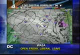
snowiest winter on record in washington. we're not done yet with the winter. let's take a look at radar now. you can see this is all that area of white is snow across most of virginia and southeastern virginia. it's rain, rain across north carolina. moderate to heavy rain is falling farther south. heavy amounts of rain are streaming in off the gulf of mexico into georgia, where you see these yellows and reds. this is all very heavy rain. this is going to conveyer belt right on up into the cold air that is in place here and as a result it's going to turn into some heavy snow. that's going to begin by later on this afternoon. right now, the local radar showing a band of some light to moderate snow, right across charles county, across the potomac river, into fairfax and loudoun county. that's the one that's now falling out at dulles. you can see the visibility's lower there with that. that's going to move into the metro area over the next half hour or so. temperatures are a little bit above freezing, so what is falling is melting on the roads, but it's going to start to stick to the grassy areas, and these temperatures that are a little bit above freezing will fall below freezing by the time we
11:22 am
get into the midafternoon hours. eastern shore, now mid-30s. mid-30s out of the mountains into the low 30s. richmond at the freezing mark. broad area under a winter storm warning. most these counties in pink, all of maryland, including the district of columbia. those counties in red on the eastern shore, blizzard warnings. yes, 3, 4-foot drifts are possible with the strong winds coming in off the atlantic as a powerful low pressure system will deep sken and lower as tim goes by this area of low pressure is barely beginning to take shape now over northern georgia. this is going to be the main low pressure system. we have a secondary low over the tennessee valley that will begin to just dissipate. but this will be the main low. and by 8:00 tomorrow morning, we will have some really strong winds coming in off of the atlantic, bringing in more moisture as well as winds gusting over 40 miles an hour, especially here right around the bay and the eastern shore. thankfully, the winds will diminish right around washington and points west. so we're not going to have those strong winds, but this storm
11:23 am
system, as it pulls away, will still have some snow behind it during the afternoon on saturday. finally, it will taper off and end by 8:00 saturday night. it will be exiting the eastern shore and pulling away and then we'll get a clearing sky and some sunshine back on sunday. but for the afternoon, snow becoming heavy over next, oh, four, five hours, certainly by sunset, which today is at 5:30 or so. then becoming very windy. temperatures right now in the mid-30s, we'll fall to near 30 as that snow does pick up in intensity overnight. now, here's the time line. it came in this morning. now that heavy snow will be moving in, perhaps by 4:00 this afternoon. then the very heavy snow will be moving in tonight. that very heavy snow zone could be snowfall rates of 1 to 2 inches per hour from 6:00 p.m. this evening all the way until around dawn on saturday. so by then, we could have about a foot or more of snow on the ground with still yet more heavy snow to come in. by saturday afternoon and evening. so here are the total amounts i expect from this storm. 18 to 24 inches will be common
11:24 am
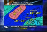
throughout the entire region. higher amounts, up to 30 inches, perhaps, from northern montgomery county into frederick county, maryland, and washington county, as well as western loudoun. those counties right along the eastern side of the blue ridge and northern fauquier county could see up to 30 inches. the shenandoah valley, 20 to 24 inches likely from this storm. may mix in a little bit of snow and sleet with some snow and rain farther south and east that may keep the amounts down a little bit there. fe finally, all this done saturday night, sun back sunday and monday, but it's not going to get above freezing. we'll see temperatures only in the 20s to near 30 degrees saturday night into sunday and monday. and finally, maybe on tuesday, a little bit above freezing, but we might get a little dusting of snow on tuesday. not a major storm, but several inches possible. and then it's going to remain cold after that. and this is the kind of snow, as ll, that's heavy and wet. tis goi this is ing to be one of those neighbors helping neighbors storms, that if you have an
11:25 am
elderly person living in your neighborhood, get out there and help them. don't let them do any shoveling. this is heavy, wet snow we'll be having, higher amounts by tomorrow morning. now the traffic. jerry, how's it looking with the snow falling? >> tom, as we mentioned earlier today, we're expecting a little bit of a mini rush hour about lunch time, and that appears to be what is happening now. this is interstate 66 outside the beltway. that's the westbound flow, headed from vienna out toward the interchanges in fair oaks and centerville, certainly picking up some volume and slowing on down. eastbound, not a concern. but, again, westbound, it's just volume. again, an early rush hour with early dismissals. a lot of people headed home before the storm. let's go to the american legion bridge. take a look at this camera while we can. i expect within the next hour, we're not going to see too much. the outer loop is fine, the inner loop, which is very typical for the rush hour in the afternoon, starting to load up very, very quickly. barbara and joe, back to you. >> thank you, jerry. 11:25 now, 35 degrees.
11:26 am

still ahead on "news 4 midday," a whole lot of shoppers disappointed. where one store got so crowded they actually turned people away. plus, loaded and ready. transportation departments across the area are stocking up on salt and sand for the weekend. and the snow is starting to move in. a closer look at when the heavy


11:29 am

the whole foods grocery store in logan circle shut down after filling to capacity with last-minute shoppers. >> yep. the "p" street whole foods closed for 30 minutes at 7:00 last night after customers packed that store. whole foods reopened and people had to shop in shifts, believe it or not, and some shoppers were in a frenzy. >> this woman was on the phone, freaking out, "oh my god, they turned us away, i need food, come on, i need food." >> it was superbusy. a lot of people in there, i guess, getting ready for the storm. >> also, the d.c. area reported the whole foods locations closed an hour early at 9:30 p.m. due to an staff meeting. i guess that's one of the other whole foods stores. >> people need to get a grip on things. time is 11:29, 35 degrees. coming up in the next half hour of news 4 midday, the snow is moving into our area. tom kierein is back with the latest on the storm's timing.
11:30 am

>> reporter: and the snow is already starting to come down here at nashua airport. luckily, a lot of folks already got out of town. we'll have reports telling you all about it, coming up. and what president obama had to say about today's storm. stay with us. we'll be right back. if i had to sit on a bench during the middle of a game
11:31 am

due to diabetes it would frustrate me. in a basketball game a couple minutes could mean a big momentum shift. my bayer meter is very important. (announcer) only bayer's contour meter has programmable personal high low settings. it allows me to be able to look at my highs and lows to make sure that my diabetes is being controlled as tightly as possible. with my bayer meter i don't miss valuable game time. i'm alana burns and staying in the game is my simple win. (announcer) the contour meter, only from bayer.
11:32 am

right now on "news 4 midday," people across our area are preparing for a long weekend of heavy snow. we're looking at a live picture at route 28 near dulles airport. can't see very much in this
11:33 am
picture. >> i'll take your word for it. >> believeme. winter storm warnings run from virginia into marynd, parts of west virginia, pennsylvania, new jersey, ohio as well, and of course here in washington, d.c., as well. and despite the approaching snow and the cold temperatures, chopper 4 found these five brave and hearty folks. they were taking a very cool morning dip in the outdoor pool at the silver spring ymca. swimming may be a little more difficult later today and tomorrow, as the temperature drops. >> i assume that pool is heated. >> i would imagine. >> i would have to assume that. >> that is not the pool you swim in, is it? >> it is not. >> you go out on a day like this? >> no. >> metro is getting ready for the snowstorm as well. steven is standing by on the telephone with the latest. good morning. thanks for joining us. >> good morning, joe and barbara. >> how are things moving right now? >> so far, things are going ll. we don't have any problems at all at metro rail, metro bus,
11:34 am
and metro access. like the rest of the region, we are anticipating the worst weather to come later on this afternoon. as a result of that, we will be making our preparations later on this afternoon and this evening, at least on the rail side. we do anticipate suspending our above-ground rail service that could come very late this evening. and in terms of our metro bus service, we anticipate, depending upon the road conditions, we would expect our buses to go to snow emergency utes some time late this afternoon. and also the possibility exists that we would be suspending all of our bus service on the roads very late this evening as well. >> okay. steven, i think i heard that once there is 8 inches of snow on the ground, the above-ground operations of metro rail has to be cut. and i'm wondering, is there no equipment that metro has or could even get that could keep those tracks clear and the third rail clear, even with 8 plus inches of snow? >> well, you know, we do have
11:35 am

equipment that can removenow and ice from the rail and the third rail, but given what the forecasts are, and especially if we're going to experience blowing and drifting snow and heavy winds during the height of the storm, anything that gets moved is going to be quickly -- it will be covered up once again. so it's going to be a monumental task, especially during the overnight hours, this evening, and into tomorrow where it's a very difficult task to constantly clear away the snow and ice and then it gets re-covered or it refreezes again. that's why we would have to move to the blow-ground service and suspend all the above-ground service. >> hopefully you will get everybody home this afternoon and this evening so that they can be tucked in and safe. >> well, good luck, steven and the metro, going to be a challenging weekend for you. >> thank you very much. >> thanks for joining us. how long before we start seeing, really, the worst of it, as it moves into our area?
11:36 am

>> tom kierein has been tracking this storm for days now. he's in storm center 4 and can give us the latest now. good morning, again. >> the storm track is continuing to show some light to moderate snow for us initially. this is a live picture in rockville right now. you can see there's some light snow there, in montgomery county. but elsewhere, the snow has picked up in intensity. all of this coming from a conveyor belt of heavy moisture off of the gulf of mexico, streaming across georgia into south carolina and north carolina, all in the form of rain, where you see the greens and yellows, that's moderate to heavy rain. but it changes over to snow, the white zone there in virginia, that is all snow, and it's continuing snowing across all of virginia, in to the district of columbia, now reaching the ground in maryland as well. and it's snowing light to moderately now. we have temperatures that are at or a little bit below freezing across most of virginia. in washington and in maryland, though, where the snow is still falling lightly, it's a little bit above freezing. so it is melting initially. a broad area under a winter storm warning.
11:37 am
it includes all of -- just about all of virginia and all of maryland. eastern shore under a blizzard warning. so is the jersey shore. most of pennsylvania, too, under some sort of warning, and that extends all the way back into the ohio valley. for the rest of the afternoon, snow becoming very heavy by sunset and becoming windy as well. gusts up to 25 miles per hour out of the northeast. the time line showing the heaviest snow begin to fall around 4:00 or 5:00 in the metro area and earlier farther south. en a very heavy snow overnight tonight, tapering off and ending by tomorrow afternoon, leaving 18 to 24 inches here across most of the region, perhaps up to 30 inches around the blue ridge and near the shenandoah valley. and then sun returns sunday and monday, but it's going to be below freezing throughout that entire time. that's the way it looks right now, barbara and joe. i'll be back with another update, shortly. >> and as we've noted, the snow is starting to come down in some areas. it could be affecting traffic already. let's find out.
11:38 am
>> here's jerry. >> all right. good morning, and indeed, the afternoon rush hour as gotten under way, no doubt about that. we'll head on over, take a live look at the beltway in maryland. this is the inner loop of the capital beltway, as you make the trip from route 355 around the bend over towards silver spring, again, the weather and the mini rush hour afternoon commute has already begun. outer loop of the beltway is doing okay. we'll head over and take a look in virginia. at this hour, this is 66 westbound, leaving the roosevelt bridge, headed out towards gleeb road. folks loading up and getting out of town now and the snow does continue. the road conditions, not bad, but again, it's just volume as the rush hour is under way. barbara and joe, back to you. >> thanks, jerry. a lot of schools and businesses are closing early today so kids can get home before the weather gets bad. d.c. public schools close at noon today. in maryland, prince jornl's county schools are closing three hours early. montgomery county schools, 2 1/2 hours early. and arundel county schools, 2
11:39 am

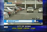
hours early. schools in carroll county, 2 hours and 45 minutes early. washington county schools, also 2 1/2 hours early. most schools in the commonwealth of virginia closed today ahead of the storm. all early dismissals and closings will be running at the bottom of your screen. d.c. mayor adrian fenty just wrapped up a press conference on the storm. the mayor says the city has declared a snow emergency. >> we declare a snow emergency in d.c. because we want people to move and keep their cars off of snow emergency routes. we need the big trucks to be able to go all the way to the curb to be able to pw on these routes that are so important for rush hour, for buses, for emergency vehicles and for residents. >> the d.c. government will close at 2:00 today. that includes all government offices, libraries, and rec centers. >> road crews will be out in force today to battle this storm and keep the roads clear. in virginia, crews have 240,000
11:40 am

tons of salt and sand available. maryland has stockpiled even more, 266,000 tons. in d.c., all five of their salt domes will be activated for this storm. >> amtrak is shutting down ahead of the storm. most trains south of d.c. have been canceled for today. that includes all southbound northeast regional trains between washington and richmond and newport news, with the exception of train 67. there is no alternate transportation. trains are also canceled between lynchburg and washington. this storm could also have a major impact on anyone trying to fly today. many people packed the airports early this morning, hoping to get out before the snow started to fall. news 4's tracee wilkins joins us from reagan national airport with more on that. a lot of folks lining up to try to get out of town, huh? >> reporter: not anymore, barbara. not like it was this morning. this morning, we had a lot of people lining up, trying to get out of reagan national airport before they thought possibly
11:41 am

cancellations and delays and other problems, because the snow's coming down, they lined up early, it was just a madhouse inside of reagan national airport. lots of people who were trying to rebook. this all started after southwest airlines got out there and said, look, we're not flying on friday afternoon nor evening. we're canceling all of our flights for saturday and most of them for sunday morning. that was affecting flyings coming out of bwi and dulles. now, of course, those passengers and other people who were worried about cancellations and delays as the storm hit decided the come down and try to get out of town. a lot of those folks were successful. some of them found it was very easy to rebook because of all of the relaxed rules with rebooking that the airlines have given folks to help make this situation a little easier with the storm, while some experienced that, others didn't. and then, of course, then there was just the issue of the long lines. >> this is crazy. i mean, i live in atlanta and our airport is much busier and never quite like this for a
11:42 am

storm. so i'm just hoping i get on my flight. >> reporter: issue getting your flight? >> no, not at all. actually, they waived the rebooking fee, which was great. >> reporter: did you have the same experience? >> no. they charged me a rebooking fee. >> reporter: i'm sorry. >> but i'm happy to be getting home. i was supposed to leave at 6:40 this evening, so i don't think i would have gotten out at that time. >> reporter: so taking a look at national airport, you can see now, i mean, the visibility is not that great, the snow's starting to come down. this is why so many people wanted to get out of here. we've already seen a couple of cancellations inside of reagan. if you have not rebooked yet, know that you should call your airline before you try and get on another flight. it's just a real mess out here at the airport. i'm tracee wilkins live this morning at national. back to you in the studio, barbara. >> thanks, tracee. our coming snowstorm is also on the prident's mind. mr. obama heads to atlanta, maryland, today to talk to small business owners about job creation. last night the president laughed
11:43 am

off some of the hysteria about the massive snowstorm headed our way saying, quote, we can handle it. power companies are preparing for possible widespread outages in our area. they'll have service work crews working throughout the weekend, but they won't know where too unless you call them. dominion virginia power customers should call 1- 1-888-773-2662. bg&e customers call 1-800-685-0123. call your utility if you suffer a power outage or see any fall in a sparking power lines. keep that cell phone at the ready, because your home phone may go out if your power goes out. if you haven't stocked up on enough food and supplies, you are quickly running out of time. the stores have been packed with people wanting to get ready for the storm. news 4's megan mcgrath joins us live from rockville where she's
11:44 am
seen some sights today. tell us about them, megan. >> reporter: oh, boy, we have seen, first of all, a lot of people. take a look at this parking lot behind me. it is very, very tough to get a parking space. there are so many people coming in. you can see them stacked up he, down on this aisle here. you've got people who are waiting, people who are pulling out. pulling out is kind of a chaotic situation here. we've heard a lot of horn blowing in the last hour or so, because the store itself is packed. let's take a look at some video shot inside a while ago when they really, really got slammed. there were so many people shopping for all of the necessities, and of course, everyone half, primarily the same thing, the bread, the milk, the cheese and those items that they had a problem with inventory at stores all around our area. just basically selling out of the necessities that people were after. i have some good news to report. this giant here, they got a number of truckloads in overnight, so they have actually been able to restock and they're
11:45 am

in pretty good shape right now. they got some more bread in, they got some milk, and a lot of the necessities here. now, folks say that they knew about the storm way in advance and they're ready at this point. >> i was asking my husband, do we have all our batteries? >> reporter: do you feel good about it, or are you can kind of dreading? >> i feel good about it, because it's friday. we drove to work together, i dropped him off, and you know, we'll be home. >> reporter: so you're ready? >> i am, i am. just picking up some last-minute things. >> the problem will be when i to shovel it from the driveway. after that, just hunker down, enjoy the football game, and we're all done. >> reporter: and you can see, we have snow coming down here in rockville. it's not sticking to anything yet, but it has begun. and of course, folks loading up their cars with those groceries, trying to get home before it really starts to get ugly out here. joe, back to you. >> okay, megan, thanks very much. i heard one of your customers out there honking his horn. probably saying, isn't this a
11:46 am
lovely day. thanks, megan. the snow could put a cramp in the capitol's plans this weekend. right now the capitals are scheduled to play at 7:00 tonight and at noon on sunday. both games are at the verizon center. as it stands right now, the games will be played as originally scheduled. however, that could change, depending on the weather. fans should check the team's website, washingtoncaps.com before heading to either game. the capitals are riding high on a 12-game winning streak. 11:46, 35 degrees. still ahead on "news 4 midday," the dow traded below 10,000 for the first time since november on thursday. we'll check on the markets this morning after some good news on the jobs front. and we all could be spending a lot of time indoors for the next few days. we'll look at how you can cut


11:49 am

the unemployment rate dropped unexpectedly in january to 9.7%. >> let's check in with cnbc's courtney reagan. she joins us live with that and the rest of the day's business headlines. >> i hope you don't get stuck in that snow. make sure you have your shovel. yesterday ended up to be one of the worst days for the dow in eight months. that's where i have to start. right now stocks are lower, but by comparison, not as bad as we saw yesterday. only down about 59 points on the dow. asian markets dropped overnight, europe lower again today. and part of the big reason for the concern around the world is really the rising debt problems in europe. not among banks, but governments
11:50 am

like greece and portugal, those countries are having trouble refinancing their debt, which makes it harder to borrow money to support their economic recovery. so if one defaults, there's fear it could spread to other european nations and possibly around the world. today, though, as you mentioned, it's jobs day and it's not as bad as it could have been. there's good news and bad news. i'll get the bad news over with first. unfortunately, 20,000 jobs were lost in january when none were expected and the december job losses have been downwardly revised to 150,000 from previously reported 85,000. the good news is, however, the unemployment rate dropped to 9.7%. that's a five-month low when it was actually supposed or expected to rise to 10.1%. and the november job gains were upwardly revised to a gain of 64,000, up from 4,000. so not all bad. and ford is offering to fix a software glitch that's affecting brakes in its ford fusion and mercury milan hybrid. the problem affects about 9,000
11:51 am

vehicles that were made before october of last year. ford says warning lights do come up on the dash and customers may feel a loss of braking, even though the system is, in fact, still working. it sounds like you get a warning li light when that shows up. take it into your dealer. >> have a great weekend. see you monday. in the dead of winter, your heater is working harder to keep your home warm. and with escalating energy costs, your bills could go up significantly this month, but a few easy steps could help you cut your heating costs and save you some money. eun yang reports. >> reporter: you want to cut your heating costs and don't want to spend a lot of money doing it. take a look around your house. home expert gena schaffer says the fixes are right around you. >> if you put your sofa on top of your floor vent, which is where your heat comes out of,
11:52 am

you're blocking that heat and essentially heating the sofa. >> reporter: open your blinds, shades, and curtains during the day and close them before sundown. the sunlight during the day helps heat your home and drawing your shades at dusk traps in the heat. >> that's a really easy one, and anyone can do that if you have some sort of window treatment without spending more money. >> reporter: you can set your ceiling fan on reverse. heat rises and a lot of it stays up near your ceiling. >> if you turn your ceiling on backwards at a low speed, it will send that heat back down. >> and shrink wrap your windows. it doesn't look as bad as it sounds. >> if you blow dry it enough, it looks like glass, so you can't tell that it's there. >> reporter: covering your windows could cut your energy bills by 30%. >> particularly what old drafty houses pay in heating bills, a minor investment could save you a lot of money over the winter. >> reporter: eun yang, news 4 today. >> other quick fixes include getting a floor pillow jamb,
11:53 am

sealing the leaks in your windows, and installing a programmable thermostat so you can lower the temperature in your home when you're not there. lowingeri lowering your thermostat by 1 degree will save you 3% on your heating bill and you won't even notice the difference. you can always wear a couple extra sweaters. wrap up, snuggle. 11:53 is our time, 35 degrees. >> meteorologist tom kierein will be back with another check of the forecast. st


11:56 am

our time right now is 11:55, 35 degrees. live look down 14th street. you can see the low-hanging clouds there, bringing the moisture, but the streets, you can still see the pavement, so that's good so far. that will change. right now, on "news 4 midday," people across the area getting ready for this long weekend of heavy snow. winter storm warnings run from virginia into maryland, parts of west virginia, pennsylvania, new jersey, and ohio this morning. >> we're going to get a final check on our forecast right now. let's go to tom kierein. >> the snow is just beginning now. as we take a look at the radar and the view around the region, it is coming down pretty hard. there's a live picture there at the airport. you can barely see national airport there. it's starting to come down pretty hard. look at all this moisture. you see the greens and yellows, that's rain. moderate to heavy rain in eastern georgia, just now coming into south carolina. that's going to be coming into the cold air in place here and giving us some of that heavy
11:57 am
snow by later on tonight. right now, we're getting light to moderate snow all around the region. temperatures are dropping a little bit, still a little bit above freezing, though, so it is melting on the roads. but in the next couple of hours, it will drop below freezing, as the heavy snow begins to move in by 4:00. and then very heavy snow overnight tonight, from 6:00 p.m. this evening until 6:00 a.m. tomorrow. it could be snowing at 1 to 2 inches per hour. we could easily pick up a foot in six hours, perhaps between 9:00 p.m. to 3:00 a.m. tomorrow morning. and leaving in its wake, by the time it's all said and done, general amounts up to 24 inches, around the region, maybe higher amounts, especially in northern parts of montgomery county and around the blue ridge, up to 30 inches or more in the higher elevation there is by the time it all ends tomorrow afternoon. then sun returns on sunday and monday, but very cold. we will not get above freezing, so what is falling and is sticking is going to be stay in place here all the way into next week. the good idea is to get the shoveling and the plowing done as soon as possible before that
11:58 am
hard freeze sets in. and we'll be here with frequent updates throughout the day and overnight tonight and into tomorrow as well. stay tuned, barbara and joe. >> hope you get a little rest. you've been a busy man the past few days. that's "news 4 midday." we thank you for being with us and invite you to stay tuned this afternoon for all the news and weather. >> we will have newsbreaks throughout the day with updates on the conditions. we hope you have a great day and a very safe weekend. >> see you monday. >> bye.

323 Views
IN COLLECTIONS
WRC (NBC) Television Archive
  Television Archive News Search Service
Uploaded by TV Archive on
